The kids are back in school since our last hike on Labor Day, though they're learning remotely from home. With the excellent September weather, I'd like to continue checking off a few alpine lakes, and Jeannie agrees to join me on a hike near Mount Margaret. We haven't been up this trail since late August 1997, on our way to Lake Lillian, before we were married! That hike was also before digital cameras and smart phones, as I have the prints and negatives in my photo album to prove it. The targeted lakes for today are Yvonne, Margaret, and Stonesthrow, with the latter requiring a bit of off-trail work. Let the adventure begin!

We drive it up the short but rocky logging road to the Lake Lillian trail head just past Snoqualmie Pass and Gold Creek Pond. Somehow, I seem to recall the parking being in a different spot back in '97, but it's hard to say for sure. I definitely remember the trail being in a clear cut for the first mile or two, but the area we're heading into now is more forest than clear cut. It begins on an old road, and is pretty steep in places, but easy hiking. At about 0.75 miles, we join the trail proper. It climbs steadily through the 25-year-old forest, with occasional views of the Snoqualmie corridor to the south and Mt., Rainier in the distance. At about 1.5 miles, we leave the new forest and enter the old one - the trees are suddenly very far apart, and about 3-4 times taller, surrounding a lovely forest path.

At about 2 miles, we reach a wide clearing and the junction with the Margaret Lake trail. This is the high point of our hike for the day, as we'll be dropping down to the lakes and will need to climb back out on the return. Disappointingly, none of the lakes are visible from this vantage point, though we do get a tree-framed view of the mountains to the north. On the other side of the ridge, the trail drops off sharply. The hillside here is extremely steep, but switchbacks in the trail make the grade manageable. In a short 0.5 miles, we have crossed into the Alpine Lakes Wilderness and reach
Lake Yvonne. Right now, it looks more like a small pond and is only a couple feet deep. I've seen many unnamed tarns and ponds that are much larger than this "lake". Perhaps it had more water in the year it was named, but nonetheless it is lake #9 checked off the list! It appears that the entire grassy area is full of water earlier in the season.
We hike the excellent trail through fields of heather and down a slight drop to reach
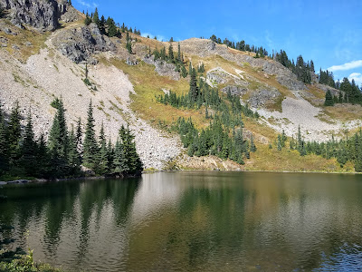
Margaret Lake, which is certainly a classic alpine lake. The mirrored surface of the water reflects fall colors on the side of Mount Margaret above. The deep water would be good for swimming, and there are plenty of campsites all around the wooded south side of the lake. I stop briefly to put my hand in the water - lake #10 complete! We make our way around the lake, finding signs of a faint trail on the far end, which is roughly where my planned route to Stonesthrow Lake should be. We pass some other hikers loaded down with buckets of huckleberries - the bushes surround the lake on the southern shore and are great for snacking this time of year.

The trail beyond the lake only lasts us about five minutes before it fizzles out. Time to switch into full-on route-finding mode. I've plotted a GPS track ahead of time, but our rather limited off-trail experience means this will be a learning experience. I know that Stonesthrow Lake is about 350' below Margaret Lake, but there is a rather steep section between the two lakes and it's hard to predict the best route via satellite photos. We initially start out down steep duff under alpine fir trees, with a bit of huckleberry thrown in for good measure. This is pretty easy going. However, before too long we come across a patch of the infamous
slide alder. For the uninitiated, slide alder is not like the big alder trees you may be familiar with. It's a low-growing alder that forms thickets, like vine maple or devil's club but more dense. You can't go over it, but you can't go under it either - you have to go through! This is not fun, because most of the time you're standing on slanted branches and can't get a foot on the actual ground. And the extra-fun thing about slide alder is it almost always grows on very steep slopes that are hard enough to traverse already. The one saving grace, if there is one to be found, is that it's easy to hold onto as you are bashing your way through it at a snail's pace.
Hopefully it is obvious from the above description, but in general, one should avoid slide alder! Unfortunately, in this case we're literally stuck between a rock and a hard place, because there is a rock outcropping to our left, and slide alder to our right and below us. I elect the safe path through the slide alder, and fortunately it only takes us a few minutes to get through it before we emerge into tall fir trees again. Phew! The way is still a bit steep, but I'll take steep duff and open forest any day over slide alder, berry bushes, or devil's club. Eventually the grade levels out as we near the lake basin. There are a lot of huckleberry bushes, but at this altitude they aren't very big, so it's pretty easy marching through them in the general direction of the lake.
Stonesthrow Lake appears as we emerge from the trees, supposedly so named for the ability of someone to throw a stone across it. It's not the most scenic lake I've seen, being surrounded mostly by boggy mud and grasses. Like Yvonne, I imagine this lake might be bigger and prettier earlier in the season. We sit down to eat our lunch on a log with a nice view of some mud and the lake.

Now, the fun part - climbing back up to Margaret Lake and the trail home. Clearly, we don't want to repeat our journey through the slide alder, so we try a more southerly route on the way back. As it turns out, there is a rather large rockslide that seems to lead most of the way back up the slope. It's very steep, but who doesn't like climbing a steep rockslide? We try to stay just on the edge of it, for two reasons: first, it can be somewhat easier to walk on the edge where there is some soil rather than plain rock. Second, we can see that at the top of this rockslide is a large cliff that we won't be able to climb, so we'll need to veer to the right to stay in the forest and have a chance of making it to the top. We pick our way up carefully, and eventually the steep talus gives way to an even steeper duff section. Fortunately, there are enough trees handy that we can pull ourselves up through the worst of it. We reach a small knoll and have an excellent view of Stonesthrow Lake that we didn't see on the way down. Just past this, we beat through a bit of berry bushes and we're back on the trail. The GPS on my phone helps instill confidence, but in this relatively modest off-trail excursion, I am sure we would find our way back pretty easily without it.
I'm always amazed at how satisfying it is to reach a trail after bushwhacking for a while - even the slightest trail is a welcome sight. We pause for a few more pictures at Margaret Lake and continue on our way back up the trail past diminutive Lake Yvonne. I imagine that Margaret Lake must be a very popular destination on summer weekends. It only requires a modest 2.5 mile hike to reach, but probably has much smaller crowds than the more well-known destinations like Snow Lake or Talapus Lake. The nearby Mount Margaret is an easy summit from the ridgetop, and Twin Lakes and Lake Lillian can be reached via the same trail.
On this day we have accomplished our three lake mission, but this won't be my final visit to this area, since Twin Lakes is still to be completed. It's a toss-up whether to visit Twin Lakes via this trail or the
Rampart Ridge Backdoor trail - the latter is easier, but I'm not sure I want to scratch up my car again on that road that gets narrower every year. Our journey back down the trail is uneventful but satisfying. Ultimately, I didn't recognize much of the trail. Whether that's due to the fog of time or due to the 23 years of forest growth, it's hard to say. Probably a bit of both.
Stats
Time: 4.5 hours
Distance: 6 miles
Elevation Gain: 2300'
Alpine Lakes Mission
Lakes visited: Yvonne, Margaret, Stonesthrow
Total lakes: 11
Percent complete: 3.7%
Photos and Videos


 Stats
Stats
Comments
Post a Comment